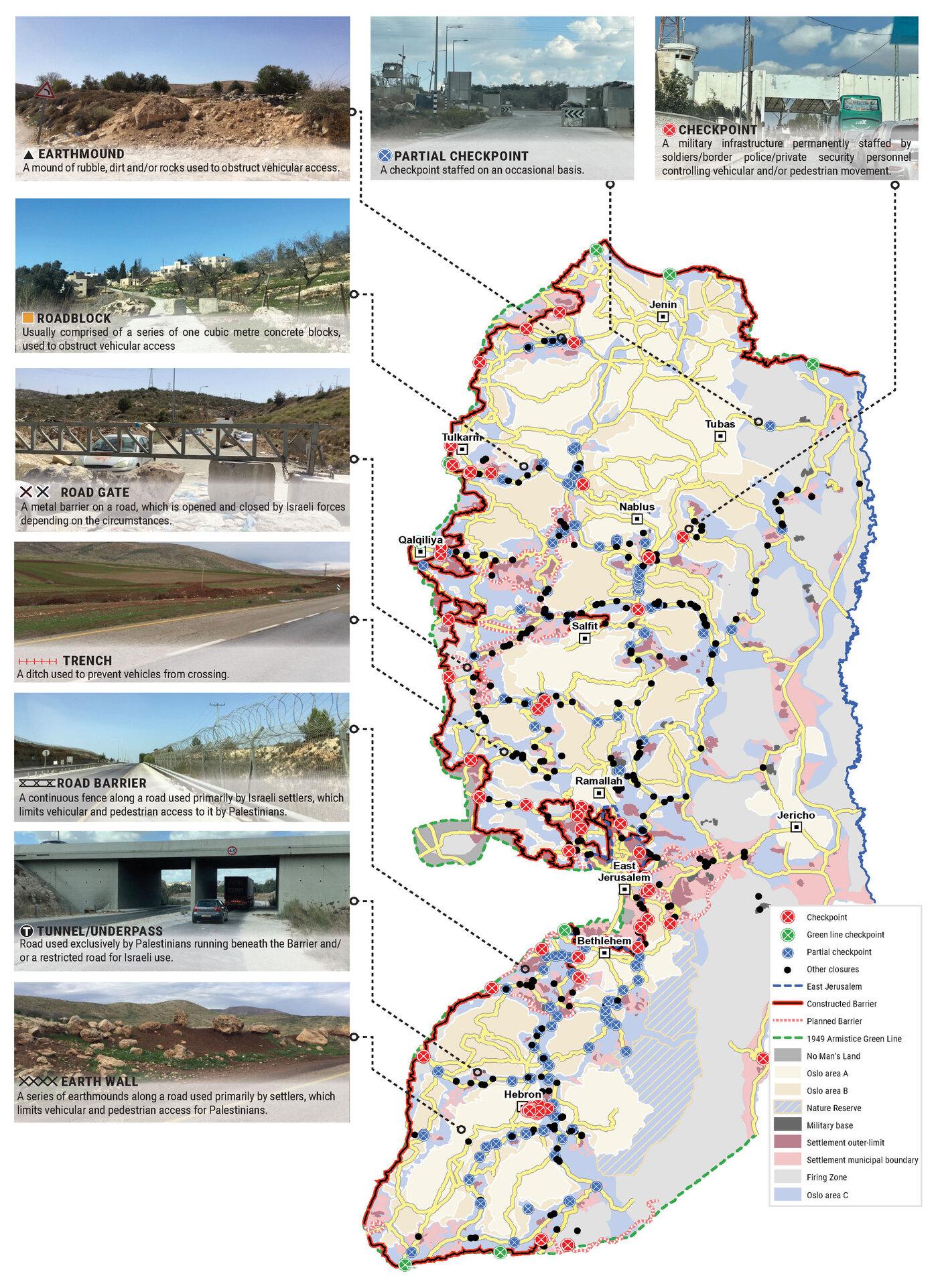
'Anin
`Anin Checkpoint is located on the separation fence, east of Mei Ami, between the village of `Anin in the West Bank and Um el-Fahm in Israel. Those who pass and return here are residents of `Anin, mostly to cultivate their lands which have been cut off from the village by the separation fence. The checkpoint opens two days a week, morning and afternoon, and daily during the olive harvest season. People go out from the village in the morning and must return the same afternoon. Anyone who does not return that same day has his permits confiscated, and until he gets ...
'Azzun 'Atma
ِِ'Azzun Atma South: South of the village, on Route 505,
which leads from Route 5 to the settlement Elkana. The checkpoint is
between the village, which is closed off by a fence, and the Elkana Seam
Zone. 'Azzun 'Atma people pass it on their way to work, usually at the
nearby settlements. It is operated by the army and open between 05:00
and 22:30.
'Azzun 'Atma North is north of the village near Beit Amin. It is the gate
to the West Bank and is used also by workers coming from the West ...
A-ram
(Updated April 2010).
A-Ras
Abu Dis
The completion of the separation wall stopped all passage between Abu Dis and Al 'Eizaria and Ras-al-Amud, which is within the 1967 borders of Jerusalem. The only passage is the so called "Pishpash" which is no more than a narrow gap between concrete plates of the Separation Wall. Used by schoolchildren and nearby residents with Jerusalem ID cards, whose names appear on soldiers’ lists.
Al Jib (Givat Zeev)
Situated next to the Giv'at Zeev filling station on road 436 (connecting Jerusalem with road 443). It started about two years ago as a crossing point for Palestinians walking from their villages in the west bank to work (mainly at building) in the Giv'at Zeev area. In 2009 it grew into a proper checkpoint with a watch tower, a car crossing and two narrow passages for pedestrians in both directions. There are checking windows in both ends.
Al Jura (Humanitarian Checkpoint)
One of the permanent manned checkpoints of the southern West Bank, on Route 35, always locked except for days of encirclement of the city. The pillbox is manned 24 hours a day.
Al Khadr
Al-Khadr served as transit from Bethlehem to Route 60. A dirt mound prevent vehicular traffic from and to Bethlehem from the west. A small market developed there. Taxi ranks were on both sides of the obstruction. It was replaced by a similar obstruction at Al Nashash which has recently been removed and thus the way from Bethlehem to Hebron through Route 60 is now free.
Al Nashshash
South of Al-Khadr, served as transit from Bethlehem to Route 60. A concrete block obstruction prevented vehicular traffic from south (Hebron) to Bethlehem and the northern West Bank. A small market developed there to replace the market of Al-Khadr. Taxi ranks on both sides of the obstruction. Usually, no on-site military or police supervision.
Al-Ezariya
At exit from Al Ezariya, before square leading to Maale Adumim. Mobile checkpoint (jeep and Border Police) operating till 09:00 am, facilitating traffic exiting Maale Adumin on three kilometer strip of road, also permissible for Palestinian vehicles. A similar checkpoint in the opposite direction, on road between Mishor Adumim and Adumim Junction. This checkpoint facilitates settler traffic on the Jerusalem-Jericho-Rift Valley road.
Anabta
Between Nablus and Tulkarm, south of Anabta village (near
Enav settlement), before the connection to Route 557. In 2009 the road
was widened and many olive trees were uprooted. The road system now
contains roundabouts and traffic lights. A year later the checkpoint was
abandoned and it is now operated infrequently. It is used by vehicles
and pedestrians alike. Israeli cars pass without any checking.
(Updated April 2010)
Ar-Ram
two kilometers south of Qalandiya and 300 metres north of Neve Yaacov Junction, in Dahiyat el-Barid Quarter. Checkpoint has operated since 1991, in a Palestinian area annexed to Jerusalem in 1967. When the Jerusalem Envelope is complete, this checkpoint will be dismantled.
Ar-Ras
on Tulkarm-Qalqiliya road (574), which passes under the Jubara checkpoint bridge. Intended for residents travelling to and from Tulkarm, so they should not cross apartheid road 557 (only permissible for settlers). It is not permanent, but checking car occurs from time to time (updated April 2010).
Awarta
East of Huwwara checkpoint, at junction of Route 557 (apartheid road forbidden to Palestinians) and access road to Nablus. Serves as transit for goods to and from Nablus. Operated by the army and open from 06:00 until 20:00. (Updated April 2010).
Beit Furik
One of the three checkpoints that used to close off Nablus, together with Huwwara and Beit Iba. Since May 2009 it has been operating for 24 hours a day, with only occasional checking of cars, which are allowed to pass freely (updated April 2010).
Beit Iba
West of Nablus and southeast of Shave Shomron settlement, between villages of Beit Iba and Deir Sharaf, has operated since 2001. One of three permanent checkpoints that closed off the city (in addition to Beit Furik to the east and Huwwara in the south).
Since March 2009 there is no presence of Israeli security forces at the checkpoint and passage is free for Palestinian. It its stead a a road block was installed near Shave Shomron (see the barrel checkpoint in Deir Sharaf) (updated in April 2010).
Betar Illit
The checkpoint is on the Green Line and serves people with Israeli identity cards travelling from Jerusalem to the Zur Hadassah area.
Bethlehem (300)
Bir Nabala (Rafat)
(Updated April 2010).
Children's Gate (Agricultural Gate 753)
In the Separation Fence, between the enclosed village Jubara and the West Bank. Passage is for Jubara people only. Special permits are given also to various suppliers. It is used by Jubara children to and fro schools, which are in the West Bank, and for teachers from the village. It is operated by the army and is open 24 hours a day (updated April 2010).
Container
Wadi Nar ("Container"/"Kiosk") - between Sawahira a-Sharqiya and Bethlehem and satellites, allowing transit only to public and commercial vehicles. Pedestrians may use turnstile without special permit. Wadi Nar Checkpoint isolates one Palestinian area from another and controls traffic between north and south of the West Bank. Prevention of transit here cuts the two parts of the West Bank off from each other.
Deir Ballut
On Route 446 parallel to Zaatra Checkpoint and close to the settlements of Alei Zahav and Peduel. Prevents Palestinians from travelling southward.
Deir Sharaf (Barrels)
The new checkpoint Deir Sharaf, west of Nablus and just below (south) of Shave Shomron settlement, a kilometer from the village of Deir Sharaf, began operation in March 2009 when Beit Iba closed. Permission to cross the Deir Sharaf checkpoint into Nablus or, via Route 60, towards Jenin, is given to Palestinians, but not to Israelis. Differing from the crossing points into Qalqiliya and Tulkarm, Palestinian Israelis are allowed to cross the checkpoint only on Saturdays.
Since April 2010 there is only a scant military presence ...
Dura/Al Fawwar Junction
One of the roadblocks (earthworks, rocks, concrete blocks or iron gates) that prevent transit of vehicles to Route 60 in the southern West Bank. There is a manned pillbox overlooking the junction.
Eliyahu Passage
On the Separation Fence, southeast of Qalqiliya, a few km from the Green
Line, on Route 55, which leads from Israel into the West Bank. It is
meant for vehicles only. Israelis pass freely. Palestinians need a
secial permit.
It is operated by the army and is open 24 hours a day.
(Updated April 2010).
Etzion DCO
serves residents of Bethlehem and surrounding villages who need magnetic cards, work permits for Israel, permits for one-time entry for religious or health reasons, various police permits, etc.
Eyal
Gate 109
Next to Eliyahu Passage, it serves as a checkpoint between the West Bank
and Israel, although is inside the Palestinian Authrity area, a few
kilometres east of the Green Line. It of the Separation Fence,
south-east of Qalqiliya. It is meant for Palestinian pedestrians with
the required permits, mainly for those working in the settlements and
for those living in the Seam Zone.
Those travelling in the direction of Israel in cars with a Palestinian number plate have to get off their car, walk to the checkpoint and join the driver who had ...
Habla
An agricultural gate in the Separation Fence in the Qalqiliya area, between the village Habla which is in the West Bank and its land, which is behind the fence. Habla farmers need a special permit in order to go through the gate. It is operated by the IDF and is locked when no soldiers are present.
Opening times - three times a day:
06:45 - 08:00
11:15 - 12:15
16:45 - 17:45
They are indicated on the gate, but no information is given to the farmers when they are changed.
(Updated April 2010)
Habla
Habla Gate 1392
This agricultural gate is situated west of the Separation Barrier, just south of the main road from Israel to the PA, off Route 55. The gate is open early morning, lunch time and afternoon, for an hour, times being dependent on the security forces' convenience and season of the year. East of the gate is the town of Habla, and west of it are numerous Palestinian nurseries, their owners holding all the lands here, many of them living in Qalqilya but having to cross the Barrier to reach their livelihoods.
Hakvasim (sheep) Junction
One of the roadblocks (earthworks, rocks, concrete blocks or iron gates) that prevent transit of vehicles to Route 60 in the southern West Bank and block the southern entrance to Hebron. A manned pillbox supervises the place.
Halhul-Hebron Bridge
Generally allows free flowing traffic, except for sudden checks by soldiers stationed permanently in the pillbox, on Route 35 in the southern West Bank.
Hamra (Beqaot)
One of the Jordan Rift Valley checkpoints that prevent direct transit between the West Bank and the Jordan Valley, in addition to Tayasir Checkpoint. Located next to Hamra settlement, on Route 57 and the Allon Road.
Hapishpash
This "checkpoint" is no more than a narrow gap between concrete plates of the Separation Wall. Used by schoolchildren and nearby residents with Jerusalem ID cards, whose names appear on soldiers' lists.
Hebron
According to Wye Plantation Accords (1997), Hebron is divided in two: H1 is under Palestinian Authority control, H2 is under Israeli control. In Hebron there are 170,000 Palestinian citizens, 60,000 of them in H2. Between the two areas are permanent checkpoints, manned at all hours, preventing Palestinian movement between them and controlling passage of permit holders such as teachers and schoolchildren. Some 800 Jews live in Avraham Avinu Quarter and Tel Rumeida, on Givat HaAvot and in the wholesale market.
Checkpoints observed in H2:
Hizma
It is next to Hizma, on the road leading from Route 60 into Pisgat Zeev,
which is in the annexed part of Jerusalem. Only holder of blue IDs,
Israeli citizens and Palestinian East Jerusalemites, are allowed
through.
It is operated by the Terminal Unit of the Military Police and Border
policemen, policemen and private security guards. It serves mainly
settlers.
(Updated April 2010)
Huwwara
South of Nablus, at the junction of Routes 57/557, between settlements of Bracha and Itamar. One of three checkpoints that close off Nablus, together with Beit Furik and Beit Iba. Among the three, Huwwara was the biggest and the most difficult one. It was established in 2001 as a checkpoint for pedestrians and vehicles. The pedestrian checkpoint was rebuilt a few times, the last of which was in March 2009, which involved moving to a completely new structure. A few months later it was abolished in the framework of improving the Palestinian movement in the West ...
Irtah (Sha'ar Efrayim)
On the Green Line north of Route 557 and south of Tulkarm, operated by a civilian manpower company. Only pedestrians are allowed through. Palestinians from all of the West Bank can pass it, provided they return the same day through it, for work, trade, health matters and visits of prisoners. Occasionally people from the north of the West Bank (i.e. Reihan) are allowed to return through Reihan.
Since March 2010 there have been reports that documents are not checked on the way back into the West Bank.
Opening hours are 04:00 - 19:00 (the early opening hour was changed ...
Jaba (Lil)
Jaba checkpoint is east of Qalandiya checkpoint. Its declared purpose is the prevention of Israeli citizens from entering Area A.
Jalame
North of Jenin, on the Green Line between Israel and the West Bank. A big terminal for the passage of Palestinians with permits allowing entrance into Israel and goods into Israel operates there.
In the course of 2009 the terminal was opened for the passage of Israeli Arabic citizens into the West Bank. Since October 2009 they may pass in their cars.
Jit Junction
At the meeting of Route 55 and 60. It started as a road block on Route 60, but became a permanent checkpoint until it was cancelled. Lately, flying checkpoints of police and border police are occasionally there.
(Updated April 2010).
Jubara (Kafriat)
On route 557, south of Tulkarm, next to Te'enim passage. In spite of being inside the West Bank, it is used as an entrance checkpoint into Israel. Nowadays it is a closed gate, which is part of the Separation Fence which closes off the village Jubara which is in the Seam Zone formed by inclusion of the settlement Sal'it. Passage through the gate is allowed to inhabitants of the near by house and to MachsomWatch women on their way to Gate 753, the Children's Gate, which is on the northern side of the village. The gate is controlled by the Te'enim passage soldiers who have ...
Makkabim
Makkabim checkpoint is at the Palestinian side of the 1949 No Man's Land, on Route 443, going, through the Palestinian territory, from Jerusalem to the Modi'in area. Israeli citizens and Israeli identity card holders as well as Palestinian permit holders are allowed through going from east to west.
Mevo Dotan
Mevo Dotan (Imriha) at the junction of the settlement on the outskirts of the village Imriha and south of the village Ya`bed, monitors the movement of Palestinians in the north-western part of the West Bank. The checkpoint became permanent when Reihan Checkpoint became privatized. The checkpoint made the passage of Palestinian workers into Israel of the Seam Zone much harder.
Since December 2009 the checkpoint is open except for occassional checking of permits and enables free movement to the Reihan Checkpoint.
Nuaman (Masmuria)
situated on the Wall route as part of "Jerusalem Envelope," in its southeastern stretch, east of Zur Baher, Um Tuba and the small Nuaman Village, on Beit Sahur road, the checkpoint will serve as the main crossing for commercial goods from the southern West Bank to Jerusalem.
Qalandiya
three kilometers south of Ramallah, in the heart of Palestinian population. Integrates into "Jerusalem Envelope" as part of Wall that separates between northern suburbs that were annexed to Jerusalem in 1967: Kafr Aqab, Semiramis and Qalandiya, and the villages of Ar-Ram and Bir Nabala, also north of Jerusalem, and the city itself. Some residents of Kafr Aqab, Semiramis and Qalandiya have Jerusalem ID cards.
A terminal operated by Israel Police has functioned since early 2006. As of August 2006, northbound pedestrians are not checked. Southbound Palestinians ...
Qalqiliya
On the road leading eastward from the city and conncting to Route 55 after 1 km. Today the passage is free.
(Updated April 2010).
Ramadin
On Routes 354/3255, completely isolated Ramadin village, east of the fence, to prevent passage into Israel. It was removed in October 2007.
Ras 'Atiya
The checkpoint is presently on the Separation Barrier roadway, manned and open 12 hours a day, from 6:30 to 18:30. West of it is the large Seam Line village whose school is attended by children from the nearby villages east of the Barrier and many of whose inhabitants have permits to work in Israel. How long this checkpoint will remain in place is unknown, since construction of the Separation Wall, just by the settlement of Alfe Menashe, east of the present Separation Barrier, is endless, as is the creation of a new road and, obviously, a new checkpoint.
Ras 'Atiya
On the outskirts of Ras 'atiya village, on the Separation Fence, in the
direction of the five villages in the Seam Zone. It is meant for
pedestrians and cars of the people trapped in the Alfe Menashe Seam Zone
and for cars with special permits. Passage of goods for home
consumption only is allowed. Larger amounts need a special
permit which needs earlier coordination . Operated by the army and open
between 06:30 and 18:30.
From 01.05.2010 , following a change in the
route of the Separation Fence, the checkpoing was moved,
Ras Abu Sbeitan
northwest end of Al Ezariya, at foot of At-Tur. Intended only for pedestrians holding Jerusalem ID cards and other appropriate permits. Site has shed and turnstiles that pass people into sophisticated terminal. Checkpoint is distant from centre of life of suburbs east of Wall, and access is difficult.
Reihan
The Reihan (old Barta'a) checkpoint is located on the separation fence, east of East Barta'a. Residents of the Barta'a Seam Zone are allowed free passage to and from the West Bank. Others, including workers who work in Israel, need a permit to cross. Settlers move freely throught the checkpoint.
Since 16 May 2007, it has been maintained by a civilian security company subcontracting to the Defense Ministry.
Functioning on the site is a large and sophisticated terminal, which includes biometric facilities for identification of the palm of the hand, and small ...
Sansana (Meitar Crossing)
On the Green Line and serves as a crossing point between Israel and Palestine. It is administered by the Terminal Authority of the Ministry of Defence.
Shaked
Shaked (Tura) Checkpoint is located on the separation fence and near the Palestinian villages of Tura and Dahar el-Malh and the settlement of Shaked. The checkpoint opens twice a day for a total of 10 hours. The transients are schoolchildren from the "seam zoon" who learn in West Bank educational institutions, farmers from both sides of the separation fence who have been cut off from their lands, pedestrians and vehicles. The names of those entitled to pass here are on lists held by the soldiers.
Since 2008 taxis and private cars with permits ...
Shave Shomron
The checkpoint is on Route 60 (the main road to the northern West Bank), opposite settlement. Has been blocked to Palestinians since disengagement from Gaza and northern Samaria.
Sheikh Saed
Shomron Gate
On the Separation Fence of Route 5 which leads to Ariel, about 2 km east of the Green Line. It serves as a border crossing between the West Bank and Israel. Only Israeli vehicles are allowed through. Palestinian cars are not allowed on Route 5 between Barkan and Shomron Gate. It is open 24 hours a day and operated by a private security company.
(Updated April 2010)
Tarkumiya
one of the permanent manned checkpoints of the southern West Bank. Will serve as a border crossing on the Green Line, including sophisticated terminal. Located on Route 35 that connects the Gaza Strip with the West Bank. The civil Administration has here a Transport Licensing Office, a station for ownership transfer, a Ministry of Agriculture Plant and Livestock Supervisory Unit. Workers and prison visits cross. Almost no regular civilian traffic.
Tarkuniya
On the Green Line, on the road that is planned to connect the Gaza Strip to Israel. It is administered by the Terminal Authority of the Ministry of Defence. It serves as a crossing point of Palestinian workers into Israel .
Tayasir
one of the Jordan Rift Valley checkpoints that prevent direct transit between the West Bank and the Jordan Valley. Located on Route 5799.
Teenim Passage
It is south of Tulkarm, on Road 557, a few kilometres east of the Green
Line. It is a border passage between the West Bank and Ixrael, although
it is inside the West Bank. Open 24 hours a day. Operated by the IDF.
(Updated April 2010)
Za'tara (Tapuah)
Junction of Routes 60 and 5 (Trans Samaria Highway), east of Tapuah settlement. This checkpoint is the borderline between north and central West Bank set by the IDF according to the quarantine policy functioning since December 2005. Through it pass vehicles and pedestrains in both directions in separate lanes for Israelis, which are not checked, and Palestinians. Operates 24 hours a day.
(Updated April 2010).


